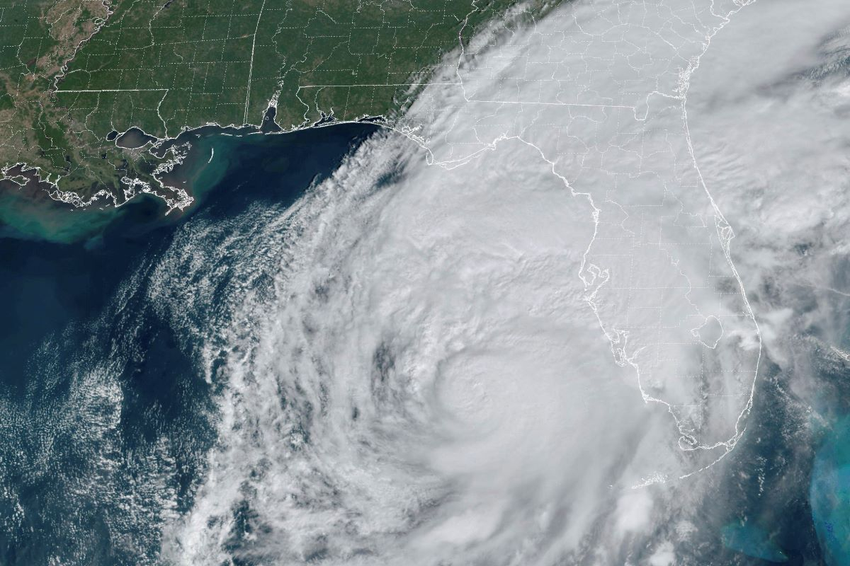

Τα πρώτα σημάδια του τυφώνα Μίλτον έχουν αρχίσει να πλήττουν τη Φλόριντα από το μεσημέρι της Τετάρτης (9/10) με θυελλώδεις ανέμους και βροχοπτώσεις, ωστόσο το φαινόμενο αναμένεται να κορυφωθεί μετά τα μεσάνυχτα της Πέμπτης (10/10) καθώς το μάτι της καταιγίδας κατευθύνεται προς τις δυτικές ακτές της.
Σε κατάσταση ύψιστου συναγερμού βρίσκονται οι κάτοικοι στη Φλόριντα για την επέλαση του τυφώνα Μίλτον, ο οποίος προβλέπεται να είναι ο πιο καταστροφικός τυφώνας που αναμένεται να πλήξει την πολιτεία τα τελευταία 100 χρόνια. Εκατομμύρια άνθρωποι κατά μήκος της ακτογραμμής άνω των 483 χιλιομέτρων έχουν λάβει εντολές να απομακρυνθούν και οι αρχές εξέδωσαν ολοένα και πιο επείγουσες προειδοποιήσεις σήμερα το πρωί, καθώς πλησιάζουν τα ακραία καιρικά φαινόμενα.
Δείτε live εικόνα από τη Φλόριντα:
{https://www.youtube.com/watch?v=HbkR1n6QZDQ}
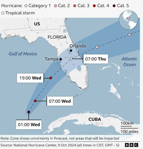
Η πορεία του τυφώνα Μίλτον προς τη Φλόριντα
Ο τυφώνας βρίσκεται σε πορεία σύγκρουσης με τη μητροπολιτική περιοχή του Κόλπου της Τάμπας, όπου διαμένουν περισσότεροι από 3 εκατομμύρια άνθρωποι, αν και οι μετεωρολόγοι λένε ότι η πορεία της καταιγίδας θα μπορούσε να μεταβληθεί πριν από την άφιξή της που αναμένεται αργά σήμερα το βράδυ.
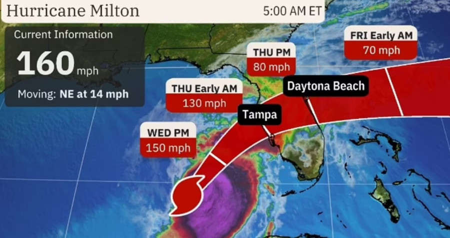
Οι εκτιμήσεις αναφέρουν ότι θα μπορούσε να χτυπήσει τη Φλόριντα περίπου στις 02:00 EDT (06:00 GMT) την Πέμπτη, σύμφωνα με μετεωρολόγο του CBS News.
Στις 16.00 ώρα Ελλάδας, το «μάτι» της καταιγίδας βρισκόταν σε απόσταση 405 χιλιομέτρων νοτιοδυτικά της Τάμπας. Η καταιγίδα εξασθένισε λίγο, σε κατηγορίας 4 κυκλώνα, ωστόσο παραμένει «ένας εξαιρετικά επικίνδυνος κυκλώνας» με μέγιστη ταχύτητα ανέμων στα 249 χιλιόμετρα την ώρα, σύμφωνα με το Αμερικανικό Κέντρο Κυκλώνων.
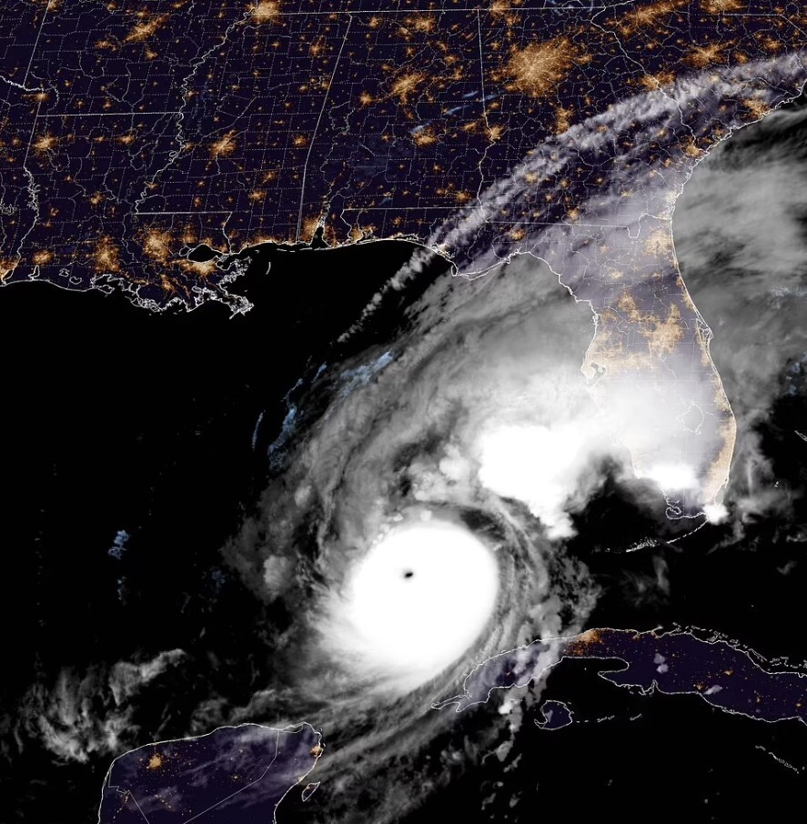
Ο Μίλτον αναμένεται να διατηρήσει την ισχύ του καθώς θα διασχίζει τη χερσόνησο της Φλόριντας, απειλώντας με καταστροφικές πλημμύρες τις ακτές του Ατλαντικού.
Αν και η ταχύτητα των ανέμων ενδέχεται να μειωθεί περαιτέρω, το μέγεθος της καταιγίδας μεγαλώνει, θέτοντας σε κίνδυνο περισσότερες παράκτιες περιοχές.
Δείτε βίντεο:
{https://www.youtube.com/watch?v=COhyFxhXBBc}
Δείτε σε πραγματικό χρόνο την πορεία του τυφώνα Milton όπως καταγράφεται στο Windy:
Πότε αναμένεται να φτάσει ο Milton στην ξηρά
Τάμπα
Διάρκεια καταιγίδας: Τετάρτη 4 μ.μ. - Πέμπτη 3 μ.μ τοπική ώρα
Μέγιστος άνεμος : 128,7- 170 χλμ. με ριπές έως 185 χλμ., Πέμπτη 12 π.μ. έως 6 π.μ. τοπική ώρα
Βροχόπτωση: 25,4 – 38 εκατοστά
Μέγιστη βροχόπτωση: Τετάρτη 2 μ.μ. - Πέμπτη 8 π.μ. τοπική ώρα
Καταιγίδα: 2,5 – 3,6 μέτρα πάνω από το έδαφος σε περιοχές επιρρεπείς σε πλημμύρες, με κορύφωση Τετάρτη 10 μ.μ. - Πέμπτη 6 π.μ. (05:00 ώρα Ελλάδας)
Σαρασότα
Διάρκεια καταιγίδας: Τετάρτη 3 μ.μ. - Πέμπτη 3 μ.μ τοπική ώρα
Μέγιστος Άνεμος: 144,8 έως 177 χλμ. με ριπές έως 225 χλμ., Τετάρτη 10 μ.μ. έως 5 π.μ. τοπική ώρα
Βροχόπτωση: 15 – 20 εκατοστά
Μέγιστη βροχόπτωση: Τετάρτη 2 μ.μ – Πέμπτη 8 π.μ τοπική ώρα
Καταιγίδα: 3,5 – 4,5 μέτρα πάνω από το έδαφος σε περιοχές επιρρεπείς σε πλημμύρες, με κορύφωση Τετάρτη 22:00 - Πέμπτη 6 π.μ. τοπική ώρα
Ορλάντο
Διάρκεια καταιγίδας: Τετάρτη 9 μ.μ. - Πέμπτη 6 μ.μ τοπική ώρα
Μέγιστος άνεμος : 112,65-144,84 χλμ. με ριπές έως 160, 93 χλμ. Πέμπτη 8 π.μ. - Πέμπτη 1 μ.μ. τοπική ώρα
Βροχόπτωση: 20,3 -38 εκατοστά
Μέγιστη βροχόπτωση: Τετάρτη 7 π.μ. - Πέμπτη 11 π.μ τοπική ώρα
Φορτ Μάγιερς
Διάρκεια καταιγίδας: Τετάρτη 4 μ.μ. - Πέμπτη 3 μ.μ τοπική ώρα
Μέγιστος Άνεμος: 40-56,32 χλμ. με ριπές έως 88,51 χλμ., Τετάρτη 11 μ.μ. - Πέμπτη 7 π.μ. τοπική ΄ώρα
Βροχόπτωση: 5-20 εκατοστά
Μέγιστη βροχόπτωση: Τετάρτη 10 π.μ. - Πέμπτη 2 π.μ τοπική ώρα
Καταιγίδα: 2,4-3,6 μέτρα πάνω από το έδαφος σε περιοχές επιρρεπείς στις πλημμύρες, με κορύφωση Πέμπτη 12 π.μ. - Πέμπτη 6 π.μ. τοπική ώρα
Σημείωση: Η Ελλάδα βρίσκεται 7 ώρες μπροστά σε σχέση με τη Φλόριντα.
Η εικόνα του τυφώνα από το διάστημα
«Πετάξαμε πάνω από τον τυφώνα Milton πριν από περίπου 90 λεπτά. Εδώ είναι η θέα από το παράθυρο του Dragon Endeavour» έγραψε αστροναύτης της ΝΑSA από τον Διεθνή Διαστημικό Σταθμό.
{https://x.com/dominickmatthew/status/1843671971566940197}
Timelapse flying by Hurricane Milton about 2 hours ago.
— Matthew Dominick (@dominickmatthew) October 8, 2024
1/6400 sec exposure, 14mm, ISO 500, 0.5 sec interval, 30fps pic.twitter.com/p5wBlC95mx
Εικόνες Αποκάλυψης με τεράστιους ανεμοστρόβιλους
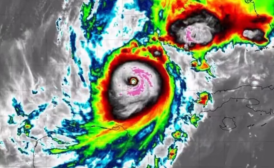
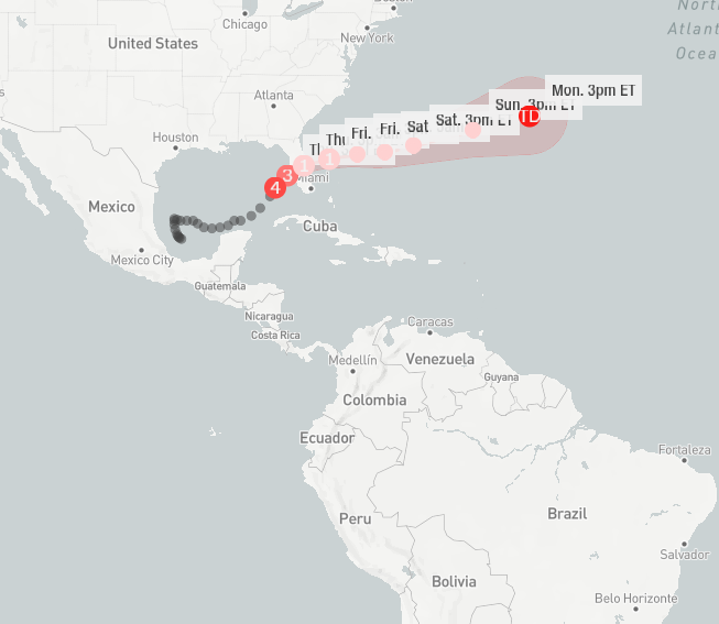
Ο Μίλτον, που περιγράφεται ως η «καταιγίδα του αιώνα», με ανέμους που εξακολουθούν να καταγράφονται στα 160 μίλια/ώρα (257 χλμ/ώρα), στράφηκε βορειοανατολικά κατά τη διάρκεια της νύχτας περίπου 480 χιλιόμετρα (300 μίλια) νοτιοδυτικά της Τάμπα, στοχεύοντας σε πυκνοκατοικημένες και ιδιαίτερα ευάλωτες κοινότητες. Αναμένεται να εξασθενήσει ελαφρώς όταν φτάσει στην ξηρά, σε κατηγορία 4 με διατηρούμενη ταχύτητα ανέμου περίπου 130 μίλια/ώρα.
Την ίδια ώρα οι ειδικοί εκτιμούν ο τυφώνας Μίλτον αναμένεται να είναι τόσο σφοδρός, που θα καλύψει σχεδόν όλες τις παραλίες της δυτικής ακτής της Φλόριντα - και θα αλλάξει για πάντα την ακτογραμμή της Sunshine State.
Τουλάχιστον το 95% των παραλιών της δυτικής ακτής της Φλόριντα προβλέπεται να πλημμυρίσει - ή να καλύπτεται συνεχώς από το νερό του ωκεανού - όταν ο τυφώνας, που προβλέπεται να είναι ένας από τους ισχυρότερους όλων των εποχών, αναμένεται να φθάσει στην ξηρά την Τετάρτη, καθώς πολλοί εξακολουθούν να αναρρώνουν από την Ελένη, σύμφωνα με το Γεωλογικό Ινστιτούτο των ΗΠΑ.
«Πρόκειται για το πιο σοβαρό επίπεδο παράκτιας αλλαγής», προειδοποίησε η ομοσπονδιακή υπηρεσία.
Σύμφωνα με τη Daily Mail αξιωματούχοι στη Φλόριντα εξέδωσαν τις τελευταίες προειδοποιήσεις για τους πολίτες που αρνούνται να εκκενώσουν τις τελευταίες ώρες πριν από την προσγείωση του τυφώνα Μίλτον, λέγοντάς τους να «φύγουν τώρα», καθώς αρκετοί ανεμοστρόβιλοι έχουν αρχίσει να πλήττουν την πολιτεία.
Εν τω μεταξύ, τουλάχιστον τρεις ανεμοστρόβιλοι αναφέρθηκαν να σαρώνουν την πολιτεία - ένας εντοπίστηκε προς τον αυτοκινητόδρομο I-75 δυτικά του Sunrise, ενώ άλλοι δύο κινηματογραφήθηκαν να στροβιλίζονται προς το Andytown και το Miles City.
{https://x.com/AlertaMinuto/status/1844042048304730528}