
Μπορεί η κακοκαιρία τις τελευταίες ημέρες του Αυγούστου να έριξε λίγο τη μέση θερμοκρασία, αλλά ο προηγούμενος μήνας ήταν ο πιο θερμός σε βόρεια/δυτική Ελλάδα και Πελοπόννησο.
Σύμφωνα με το δίκτυο των 53 μετεωρολογικών σταθμών του Εθνικού Αστεροσκοπείου Αθηνών που λειτουργούν ανελλιπώς από το 2010 μέχρι σήμερα, τον φετινό Αύγουστο η μέση τιμή των μεγίστων ημερήσιων θερμοκρασιών κυμάνθηκε σε υψηλά επίπεδα στο σύνολο της χώρας, σε σχέση με τον μέσο όρο της περιόδου 2010-19.
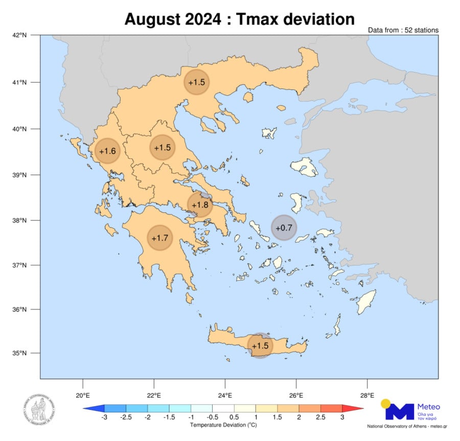
Ο φετινός Αύγουστος (όπως ο Ιούνιος και ο Ιούλιος) χαρακτηρίστηκε από πολλές και συνεχόμενες ημέρες με μεγάλες θετικές αποκλίσεις θερμοκρασίας και ήταν o πιο θερμός Αύγουστος από το 2010 στη βόρεια – δυτική Ελλάδα, στο Ιόνιο και στην Πελοπόννησο, με τις μέσες μηνιαίες τιμές να κυμαίνονται έως και 1,8°C πάνω από τα κανονικά για την εποχή επίπεδα. Στα υπόλοιπα γεωγραφικά διαμερίσματα (με εξαίρεση τη Θεσσαλία 3ος θερμότερος) καταγράφηκε ως ο δεύτερος θερμότερος από το 2010 (παραμένει ως θερμότερος ο Αύγουστος του 2021).
Ο παρακάτω χάρτης δείχνει τις αποκλίσεις της μέσης μέγιστης θερμοκρασίας τον Αύγουστο 2024 ανά γεωγραφικό διαμέρισμα.
Όπως φαίνεται στο επόμενο γράφημα στο οποίο παρουσιάζει την κατάταξη του μήνα Αυγούστου ανά έτος, ανάλογα με τη μέση μηνιαία τιμή της μέγιστης θερμοκρασίας, ο Αύγουστος του 2024 ήταν ένας πολύ θερμός μήνας σε συνέχεια των Ιουνίου και Ιουλίου 2024. Οι μέσες τιμές του μήνα να είναι σχεδόν 1°C πάνω από τον δεύτερο θερμότερο (Αύγουστος 2021) σε βόρεια και δυτική Ελλάδα.
Συνεχόμενες θετικές αποκλίσεις σημειώθηκαν σε όλη τη χώρα από τις αρχές του Αυγούστου έως το τέλος του μήνα, κυρίως σε βόρεια Ελλάδα, δυτική Ελλάδα, Ιόνιο και Πελοπόννησο της τάξης των 6-8°C πάνω από τα κανονικά για την εποχή επίπεδα. Μικρές αρνητικές αποκλίσεις σημειώθηκαν μόνο στα νησιά του Αιγαίου και στην Κρήτη με την παράλληλη επικράτηση του μελτεμιού.

Καιρός; Η ζέστη τον Αύγουστο σε Αθήνα και Θεσσαλονίκη
Στην Αθήνα, η μέση μηνιαία τιμή απόκλισης της μέγιστης θερμοκρασίας ήταν +1,2°C, με 25 από τις 31 ημέρες του μήνα να είναι θερμότερες από τα κανονικά για την εποχή επίπεδα. Στη Θεσσαλονίκη, 24 ημέρες του μήνα ήταν θερμότερες από τη μέση τιμή της περιόδου 2010-19, όπου η μέση μέγιστη θερμοκρασία του μήνα κυμάνθηκε 1,1ºC πάνω από τα κανονικά επίπεδα.
Στο 60% των 52 σταθμών οι 25 ημέρες (τουλάχιστον) από τις 31 του μήνα ήταν θερμότερες από τα κανονικά.
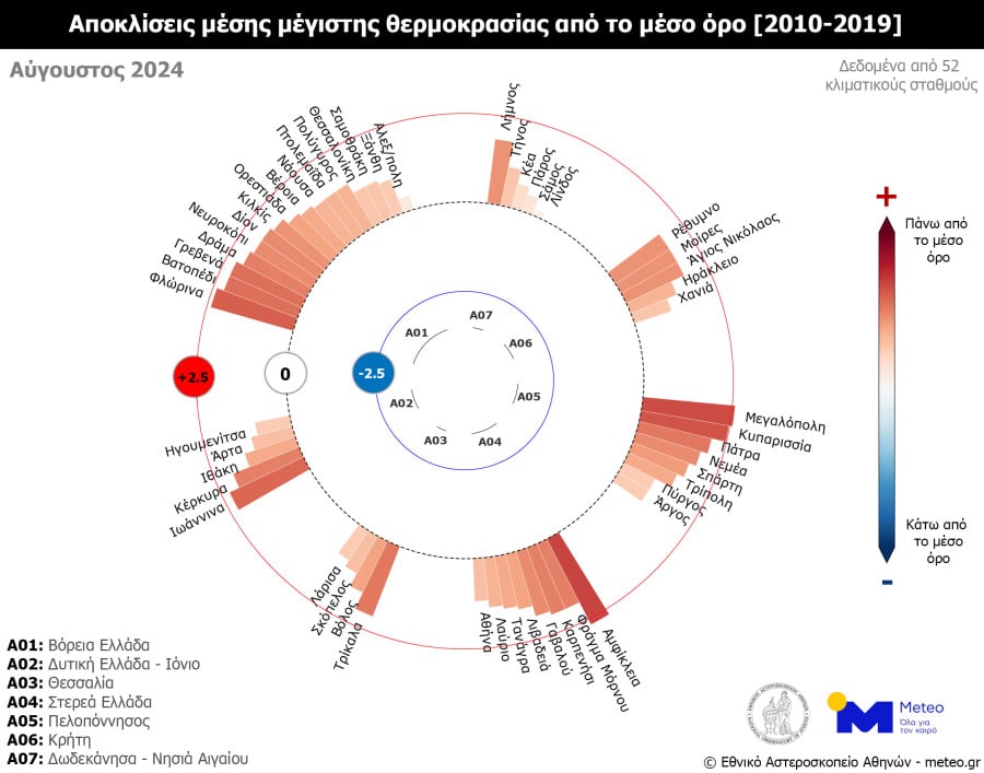
Στο τελευταίο γράφημα εμφανίζονται οι τιμές των αποκλίσεων και για τους 52 μετεωρολογικούς σταθμούς.